
All Around the World with the Most Travelled Indian
 By Nitin Gairola
I was always fond of the big picture, of the really major features and forces of nature on Earth. And simply the biggest of them all in my view is the force moving the land below our feet and we prosaically call it Plate Tectonics. As a quick school geography refresher, our imperfect blue sphere called Earth goes to a depth of almost 6,400 kilometres, right upto the solid inner core. The inner core is covered by the outer core, and then comes the lower and upper mantle and finally the outermost layer called the crust. We also use the terms lithosphere and asthenosphere when explaining the topmost layers. The lithosphere, where tectonic plates are formed, includes the crust and the topmost part of the mantle (‘lithos’ means stone in Greek). The asthenosphere is the semi-molten layer right below the lithosphere and the heat and pressure in this layer causes plasticity which allows the tectonic plates above to move.
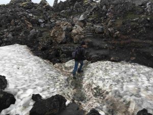
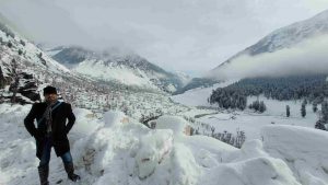
The thin crust is, on average, just 40 kilometres thick over continental land and only around 5-10 kilometres thick over the ocean floor and it is definitely not static and stationary. If it were, the Earth would not be a living breathing planet that it is and my recent experience at the Erta Ale volcano in Ethiopia got me thinking about what makes the Earth tick and that maybe I could write a piece on what we are sitting on. In fact our Uttarakhand is on a major plate interaction point too that has caused the mighty Himalayas to form around 50 million years ago or mya (they are big but young on the geological timescale). This unfortunately is also the reason for living in the fear of the next big earthquake.


So what happens is that the extreme heat and pressures of the asthenosphere causes the rocks to be in a semi liquid molten state and the convection currents in this layer cause the lithosphere and the crust above to move, albeit at a snail’s pace. We are talking about movement in centimetres and inches, anywhere between 0.5 to 6 inches every year. Our own Indian plate pushes into Asia at around 2 inches per annum. This movement has cracked the Earth’s upper layer over time into multiple major and minor continental plates. Some of the largest ones are the Pacific plate, the Eurasian, African, North and South American, Australian, Antarctic, Nazca and the Indian plates. Then there are the slightly smaller (but major) plates such as the Arabian, Philippine, Caribbean, Scotia, Cocos, Somali, Anatolian, Juan De Fuca and Rivera plates. Finally we have a host of minor sub-plates that broke from the major ones over millions of years.


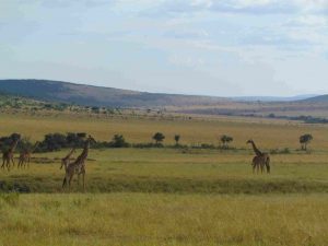
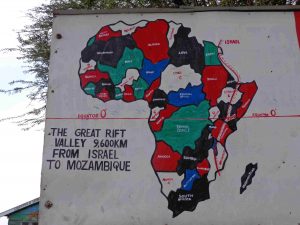
You might have heard of supercontinents in Earth’s deep past such as Pangaea (335 mya) and Gondwanaland (175 mya). These were basically the current continents (i.e. the land above sea level) when they were all bunched together by the tectonic forces below. Over time they drifted apart due to the same forces and today the tell-tale signs are there for all to see – just notice how well South America fits into Africa like a jigsaw piece. Even Africa is now splitting apart at the ‘Horn of Africa’ as the Somali plate moves away from the main African one and the proof of that is the Great Rift Valley. One day few million years later, someone in the sky will say – ‘look, how well these two land masses fit together’. This is of course assuming that humanity survives till then, in some shape and form.

Now there is a reason why this force of plate tectonics gives rise to astonishing landforms such as mountains, volcanoes and rift valleys besides being the force behind the dreaded quakes. So basically different plates interact with each other in areas known as plate boundaries and they do so in 3 different ways. We have the convergent boundaries where two plates collide into each other and this causes one plate to slide under the other, forming a subduction zone. This can result in formation of mountains and the weak spots can cause the magma to come out in a volcanic activity. Also the sudden movement of these plates (under pressure) can cause earthquakes. Then there is the divergent boundary where plates move away from each other and this can also cause the magma to come out from stretched weaker spots thereby forming shield volcanoes, such as Erta Ale which we saw in Ethiopia. This divergence forms rift valleys as well and the biggest example of that is the Great Rift Valley in East Africa. The third type is what we can transform boundaries and here two plates slide by each other horizontally and this leads to earthquakes but doesn’t create mountains. A famous example is the San Andreas Fault line in California, USA.

The reason why I am so fond of plate tectonics is because they are the reason why we have such incredible beauty to behold on Earth. Frankly it’s why we have life itself on Earth since without this constant land churn we wouldn’t have the biosphere that we have today i.e. the forests, the grasslands, the deserts, tundra and the wildlife on it. Nor would we have the atmosphere (all gases such as nitrogen, oxygen, carbon dioxide…) or the hydrosphere (all salt & fresh water bodies including oceans, seas, lakes, rivers and the life forms inside them…).
In my travels around the world, I have been over every major and minor continental & oceanic tectonic plate and have even see plate tectonics in action – at the Mid-Atlantic ridge that cuts right through Iceland and in that sense the young island of Iceland is half in North America and half in Eurasia – a meeting point of sorts. There I could see the Earth that had been cut open and could look down at the rocks that were part of the crust. I have also seen the result of these tectonic plates by being to almost every major mountain range on Earth (including the longest of each continent) and seen Rift Valleys and Volcanoes, although I doubt if I will be able to visit every volcano on Earth since there are a staggering 1,500 active ones on this planet. In any case, I won’t stop visiting such places of astounding beauty and danger and somehow these two things go hand in hand. It’s no different in the Himalayas and in our mountain state of Uttarakhand. Our Uttarakhand should really be the ultimate dopamine & adrenaline release solution for the adventure traveller.
Nitin Gairola is from Dehradun and has travelled the natural world more than almost any Indian ever. He has set world travel records certified by India Book of Records, has written for Lonely Planet, and holds National Geographic conservation certifications. He is also a senior corporate executive in an MNC and in his early days, used to be a published poet as well. More than anything else, he loves his Himalayan home. Reach him at: www.facebook.com/MostTravelledIndian/


